The PARASOL mission
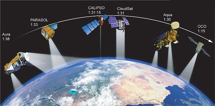
The PARASOL (Polarization and Anisotropy of Reflectances for Atmospheric science coupled with Observations from a Lidar) mission defined in 1999 characterizes the radiative properties of clouds and aerosols by taking advantage of its complementarity with the other instruments in the A-Train formation, which include the CERES and MODIS radiometers onboard the Aqua satellite, a lidar onboard CALIPSO and a radar onboard CloudSat.
The PARASOL payload draws extensively on instruments developed for the POLDER (POLarization and Directionality of the Earth’s Reflectances) program, while the spacecraft bus benefits from previous developments on Demeter, the first one of CNES’s Myriade line of microsatellites. The resulting reduction in costs and lead times allowed CNES to develop and build the satellite in less
than three years.
CNES (Centre National d’Etudes Spatiales) is responsible for the bus, payload command control and ground segments, while the LOA
(Atmospheric Optics Laboratory) in Lille, leads the science mission. LOA heads a science working group of researchers from
laboratories affiliated to CNRS, the French National Scientific Research Centre: the LMD (Dynamic Meteorology Research Laboratory), the LSCE (Climate an environmental Science Laboratory) and the SA (Aeronomy Research Laboratory).
The ICARE Data and Services Center (Lille) is in charge of the POLDER/PARASOL level-2 and level-3 production and distribution of derived atmospheric products. Level-1 data is distributed by CNES and ICARE (See Overview section).
The synergy between Aqua, CALIPSO, CloudSat and PARASOL within the A-Train imposed a number of constraints onto the PARASOL mission. The local equator-crossing time has to be carefully adjusted with respect to Aqua (around 1:30 pm) and CALIPSO, which trails Aqua to the east by nine minutes. Furthermore, the launch trajectory had to be
orchestrated by CNES operations team as part of an ultra-precise orbital choregraphy to position PARASOL accurately in the constellation.
PARASOL was launched on December 18, 2004.
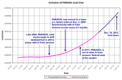
The PARASOL scientific mission started on March 12, 2005 after a 3-month commissioning phase. PARASOL flew within about 30 seconds of the CALIPSO and CloudSat satellites. During the spring in 2009, PARASOL orbit tracks slowly drifted eastward due to insufficient fuel supplies but observations were still in phase with the other sensors.
After nearly 5 years of concurrent observations with the other satellites from the A-Train, PARASOL was moved to a lower orbit (3.9 km beneath) at 12:48 UT on December 2, 2009. On the new orbit, observations from PARASOL were no longer simultaneous with the other sensors, except for only a few days at regular intervals. PARASOL had left the A-train orbit but kept acquiring observations in science mode while slowly drifting toward later overpass times. As time went on, the overpass time of the PARASOL mission departed more and more rapidly from its original value (1:30 pm). As of February 2012, there was no more overlapping at the equator with the other sensors of the A-Train constellation. For example, PARASOL was crossing the equator at approximately 3:00 pm local time in October 2012. This graph shows the evolution of the local time over the mission duration:
The drift does not significantly affect the quality of the products, but leads to a significant modification on solar geometries during acquisitions.
The science mission ended on October 11, 2013, when the decommissioning phase began. The satellite was shut down permanently on December 18, 2013.
With 8 years and 7 months of useful observations, the PARASOL mission largely exceeded the initial life expectancy of 2 years. The PARASOL mission is a success in demonstrating the usefulness of directional polarized measurements and the scientific outcome of the mission also exceeds the original objectives. PARASOL contributes to global characterization of aerosol and cloud radiative and microphysical properties. Many climatologies of aerosols, clouds, water vapor, and earth radiation budget have been produced and are publicly available (see PARASOL gallery). Moreover, the good quality of the measurements and innovative inversion methods, using PARASOL data alone or combined with other data sets, leads to unique science products.
Thanks to polarization, it is possible to get the size of the droplets at the top of the clouds or information on aerosols even over bright surfaces. Also, the combination of POLDER observations with other observations from the constellation, such as the lidar and/or the radar, led to new parameters not envisioned at first, e.g. the macro-physical properties of clouds (altitude and geometrical thickness) or the presence and the quantization of aerosol plumes over cloudy areas.
The full archive of PARASOL observations has been reprocessed in 2014 and the latest version of all products is available at the ICARE Data and Services Center (See the Products section for details).
The POLDER/PARASOL missions timeline
Three POLDER instruments have flown in 1996-1997 and from 2003 to 2013 collecting unprecedented Earth observations.
POLDER-1: Launched in November 1996 – Loss of ADEOS-1 satellite in June 1997, 8 full months of useful data. Details on POLDER-1 mission events can be found on the CNES web site.
POLDER-2: Launched in April 2003 – Loss of ADEOS-1 satellite in October 2003, 7 months of useful data. Details on POLDER-2 mission events can be found on the CNES web site.
PARASOL: Launched in December 2004 – decommissioned in December 2013, improved sensors and technology, part of the A-Train constellation of sensors, exceeded its two-year design life and collected observations for 8 years 7 months. A timeline of the PARASOL mission can be found on the CNES web site. Major events are highlighted on the ICARE PARASOL news page.
Milestones in the PARASOL lifetime:
2015/06: Release of the latest version of all PARASOL products
2014/12: End of PARASOL Level-2 and Level-3 data reprocessing by ICARE with improved and new science codes
2014/11: End of PARASOL Level-1 data reprocessing by CNES
2013/12: End of the PARASOL mission
2013/10: End of the PARASOL science mission. Beginning of the decommissioning phase
2010/10: « Symposium on the A-Train Satellite Constellation », New Orleans, USA
2009/12: PARASOL left the A-Train (moved to a lower orbit)
2007/10: « A-Train Lille Symposium 2007 », Lille, France
2005/03: Beginning of the PARASOL science mission
2004/12: PARASOL successful launch by Ariane 5
Scientific objectives
The PARASOL mission aims at measuring polarization and directionality of reflectances in coincidence with observations from the lidar onboard
CALIPSO. Solar radiation becomes polarized when scattered by certain particles such as aerosols, water droplets or ice crystals.
Parasol measures light polarized in different directions to characterize clouds and aerosols more accurately than
traditional methods that only rely on their spectral signature.
Data collected by PARASOL allow scientists to determine the quantity and size distribution of aerosols over oceans, their turbidity
index over land surfaces, and evaluate their influence on solar radiation. PARASOL also helps detect clouds, determine their
thermodynamic phase, altitude, optical thickness, and estimated reflected solar flux. Integrated water vapor content is estimated too.
The POLDER/PARASOL Instrument
Since the Japanese satellites ADEOS-1 and ADEOS-2 were lost in June 1997 and October 2003, with each a POLDER instrument onboard,
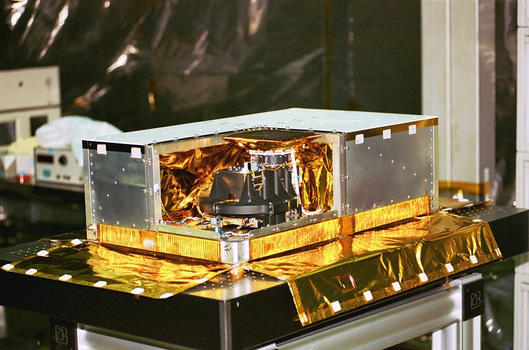
PARASOL offers a new opportunity for the climate change research community to take advantage of the POLDER original instrument concept. The instrument was
designed by the Atmospheric Optics Laboratory (LOA). It includes:
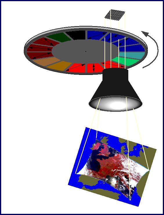
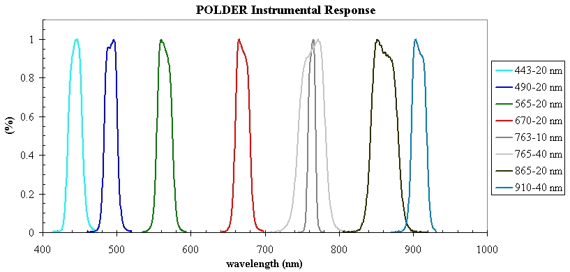
The instrument has nine spectral channels (443, 490, 565, 670, 763, 765, 865, 910 and 1020 nm), three of which with polarized filters (443, 670, and 865). Since it acquires a sequence of images every 20 seconds, the instrument can view ground targets from different angles and up to 14 different viewing angles per pixel for a single satellite pass. A scene (a 2D image) has a size of about 1600 km (along-track) x 2400 km (cross-track) with a ground spatial resolution of 5.3 km x 6.2 km at nadir. Compared to POLDER, the PARASOL sensor array was rotated 90 degrees to favor multidirectional observation over daily global coverage. Likewise, a 1020 nm channel was added to make measurements to compare to data acquired by the lidar onboard CALISPO. Spectral responses are available for : POLDER-1 POLDER-2 PARASOL |

