Product Documentation

Version history

Version 1-03: Released September 2016. First public version of GEOCLD-SAFNWC products produced by ICARE with the v2008 version of the SAFNWC algorithm.

Cloud product availability

The table below summarizes the product availability since the Megha-Tropiques launch. All products are distributed by ICARE.
For details on differences between versions v2008 and v2013, see information on the Megha-Tropiques Science web site.
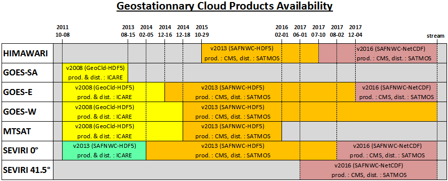
SAFNWC_History.PNG

Data access for geostationary cloud products

Information can be found on the data access page for the geostationary cloud products: data access web page.

File description: MT_GEOCLD-SAFNWC/CT


Product file format: HDF5

Product datasets

Dataset DataType Dimensions units valid_range scale_factor add_offset _FillValue Missing_Output long_name
01-Palette uint8 [?,
?]
NONE NONE NONE NONE NONE NONE NONE
CT uint8 [?,
?]
NONE [ 1 19] 1.0 0.0 0 20 Cloud Type
CT_Phase uint16 [?,
?]
NONE [1 2] 1.0 0.0 0 3 Cloud Phase (inactive)
CT_Quality uint16 [?,
?]
NONE [ 1 1017] 1.0 0.0 0 0 CT Quality Flags
Spectral_Channels struct [?] NONE NONE NONE NONE NONE NONE NONE


Product global attributes

Global attribute DataType Dimensions Value
Icare_ID string 1 RFU
File_Name string 1 MT_GEOCLD-SAFNWC-MSG2_2009-06-01T03-00-00_CT-globe+000.0-G_V1-03.h5
Mission string 1 MT
Product_Name string 1 GEOCLD-SAFNWC
ByProduct_Name string 1 CT
Product_Description string 1 Cloud classification and cloud phase from geostationnary satellites
Product_Version string 1 1.3
Software_Version string 1 1.3.0
Production_Center string 1 ICARE Data and Services Center
Production_Date string 1 2011-11-09T14:02:16Z
Contact string 1 contact@icare.univ-lille1.fr
Reference string 1 SAF/NWC/CDOP/MFL/SCI/ATBD/01 - Algorithm Theoretical Basis Document for Cloud Products (CMa-PGE01, CT-PGE02 & CTTH-PGE03 v1.4)
Slot_Nominal_Date string 1 2009-06-01T03:00:00Z
Beginning_Acquisition_Date string 1 2009-06-01T03:00:10Z
End_Acquisition_Date string 1 2009-06-01T03:12:40Z
Geographic_Projection string 1 GEOS
Region_Name string 1 globe+000.0
Sensors string 1 msg2
SAFNWC_Algorithm_Version string 1 1.4
HDF_Version string 1 HDF5 v1.8.1
Run_Statistics string 1 ------------ CT Internal Quality Check Results -----------

Region processed : globe+000.0
Region channel flag : VIS_IR
Region centre : line 1856 column 1856
Product size : lines 3712 cols 3712
Product time slot : 200906010300

----------------------------------------------------------
NWP availability 99.93%
GEOSTAT availability 99.48%
----------------------------------------------------------
CT quality 83.77%
CT completeness 99.27%
----------------------------------------------------------
clear_land 25.07%
clear_sea 18.29%
snowice_land 0.00%
snowice_sea 0.00%
vlow_cum 0.00%
vlow_nocum 11.97%
low_cum 0.00%
low_nocum 7.71%
med_cum 0.00%
med_nocum 4.04%
hi_opaq_cum 0.00%
hi_opaq_nocum 4.21%
vh_opaq_cum 0.00%
vh_opaq_nocum 1.66%
semitr_thin 3.23%
semitr_mean 11.03%
semitr_thick 2.92%
semitr_above 0.82%
fractional 9.04%
undefined 0.00%
----------------------------------------------------------
Processed FOVS with NWP quality information 100.00%
Processed FOVS with GEOSTAT quality information 100.00%
Processed FOVS with View cond. quality information 100.00%
----------------------------------------------------------
Processed FOVS with phase non processed 100.00%
Processed FOVS with water phase 0.00%
Processed FOVS with ice phase 0.00%
Processed FOVS with undefined phase 0.00%
----------------------------------------------------------
Projection_Longitude float64 1 0.0
Sub_Satellite_Longitude float64 1 0.0
Nadir_Pixel_Size float64 1 3.0
Number_of_Columns_in_Region int64 1 3712
Number_of_Rows_in_Region int64 1 3712
Parameters_Count int64 1 3
SGS_Product_Quality int64 1 84
SGS_Product_Completeness int64 1 99

Autodpc 1.2.5 - © 2012 - ICARE Data and Services Center


back to the top

Search